 This bridge has a somewhat unique history. It was originally built over the Thomas Creek in Linn County several miles east of Scio. When Linn County announced the aging Jordan Bridge was to be replaced in 1986, Stayton residents asked if they could take title to the structure. A covered bridge preservation company was formed, enlisting the help of numerous volunteers and Marine Corps reservists for the 6th Engineering Battalion in Salem. The span was rebuilt over the Salem Power Canal to serve as a foot bridge connecting two parks. The process of rebuilding the Jordan Bridge occupied nearly two years, culminating in a dedication ceremony in June 1988.
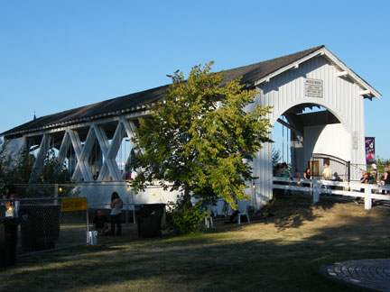
 In 1994, the bridge caught fire on December 20th when Christmas lights ignited the roof. It was a total loss. Local citizens worked throughout 1997 and 1998 to construct a new covered bridge at the site. The new bridge incorporates glue laminated members for added strength. The rebuilt bridge was dedicated in September 1998.
To get to the bridge, I rode from Silverton south on Hwy 211. If you are in need of zen moments, it's a very, very nice area to putter through. The roads are in excellent condition and not much travelled. There is excellent parking available so access to the bridge is possible regardless of whether you ride or drive. Picnic tables are sprinkled throughout the park so bring along a picnic lunch/dinner to enjoy some downtime there. Kids were playing in the water so there's a number of ways to enjoy the location.
Latitude: 44°47'55.2"N, Longitude: 122°47'09.2"W


 Built in 1939, the bridge had to be rennovated in 1998 after a careless load handling incident damaged the internal support structure. The railroad runs right next to the bridge, which apparently put the town of Gilkey on the map as a point of shipping for local farm goods. Those days are long gone and now you hardly realize you are passing through a town except for a collection of closer spaced homes with the most wonderful smells of baked goods (it was about time for dinner and I think I was getting hungry). The bridge spans 120 feet over Thomas Creek. Very charming farming area. The roads to access the bridge are in excellent condition.

